Zuheros
Around Córdoba
This page describes some walks in March 2013 based mostly around Córdoba. The weather was pretty poor - often wet and cold (if you’ve been there in the summer, you have to ask “how can Andalucia be cold?!?”), so the walks were rather ‘bitty’ and unsatisfying....however, some nice cultural and natural sights, as always when on foot...!
This page describes some walks in March 2013 based mostly around Córdoba. The weather was pretty poor - often wet and cold (if you’ve been there in the summer, you have to ask “how can Andalucia be cold?!?”), so the walks were rather ‘bitty’ and unsatisfying....however, some nice cultural and natural sights, as always when on foot...!
Sevilla and Écija
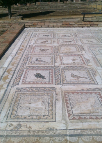
Before arriving at Córdoba, I spent a day in Sevilla, in particular visiting the Roman city of Italica at Santiponce, 9 km to the northwest. I thought about doing this on foot, but navigating through the Spanish main roads deterred me, so i caught the bus from Plaza des Armas bus station; I believe, however that the route of the Via Plata goes there, so it may be better signed than I thought? Its a nice site - not overhyped, with good mosaics and a very well preserved amphitheatre.
The bird mosaic at Italica.
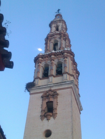
I also spent a couple of days in Écija, halfway towards Córdoba. It’s famous for its baroque churches, but also has a rich roman and (less so) moorish history. It was too rainy to do much more than explore the town and go on some short local excursions. The Rio Genil, which the town sits on was a raging torrent at the rime, with huge branches being tossed around as it thundered north, and the town had recently suffered from flooding. I’m sure this isn’t typical.
The tower of Écija's St Gil church, with the moon above a stork's nest.
The tower of Écija's St Gil church, with the moon above a stork's nest.
Córdoba - Medina Azahara
This objective of this day was simple - to visit the site of the famous Moorish palace, only 5km west of Córdoba, and then find a way back to the city through the Sierra Morena foothills to the north. I didn’t have a proper map, but had a Turismo street plan. Medina Azahara is clearly visible from the main Sevilla-Córdoba road and rail links, sitting just above the Guadalquivir floodplain, so it is fairly straightforward to head in its direction straight from the train station. On the edge of Córdoba, I found myself in what seemed like a pretty run down Poniente Norte housing estate....lots of folk hanging around, presumably part of Spain’s massive unemployment problem, patronising a few cheap clothes stalls, barbecuing fish and so on. It felt slightly uncomfortable - not many tourists in this zone I think, but it was no hassle to walk through and out of the city. Spanish cities often seem to end very abruptly - one moment a block of flats, the next a field. Medina Azahara was now visible to the right ahead, but it seemed impossible to avoid walking on the verge of the busy A431 road. A cycle track edges the road in many places, but its not continuous and there’s lots of broken glass, so its not particularly pleasant. At the turnoff to the site, a stork was nesting, and the gleaming visitor centre is quickly reached; the site itself is another 2km or so further up. A thunderstorm passed over, always nice to watch from under cover! The site is interesting enough, but not very easy to make sense of. The maps and arial photographs in the interpretation centre on the actual site showed lots of moorish bridges, roman sites etc in the vicinity and their relationship to Medina....lots of possibilities to explore perhaps another time?
This objective of this day was simple - to visit the site of the famous Moorish palace, only 5km west of Córdoba, and then find a way back to the city through the Sierra Morena foothills to the north. I didn’t have a proper map, but had a Turismo street plan. Medina Azahara is clearly visible from the main Sevilla-Córdoba road and rail links, sitting just above the Guadalquivir floodplain, so it is fairly straightforward to head in its direction straight from the train station. On the edge of Córdoba, I found myself in what seemed like a pretty run down Poniente Norte housing estate....lots of folk hanging around, presumably part of Spain’s massive unemployment problem, patronising a few cheap clothes stalls, barbecuing fish and so on. It felt slightly uncomfortable - not many tourists in this zone I think, but it was no hassle to walk through and out of the city. Spanish cities often seem to end very abruptly - one moment a block of flats, the next a field. Medina Azahara was now visible to the right ahead, but it seemed impossible to avoid walking on the verge of the busy A431 road. A cycle track edges the road in many places, but its not continuous and there’s lots of broken glass, so its not particularly pleasant. At the turnoff to the site, a stork was nesting, and the gleaming visitor centre is quickly reached; the site itself is another 2km or so further up. A thunderstorm passed over, always nice to watch from under cover! The site is interesting enough, but not very easy to make sense of. The maps and arial photographs in the interpretation centre on the actual site showed lots of moorish bridges, roman sites etc in the vicinity and their relationship to Medina....lots of possibilities to explore perhaps another time?
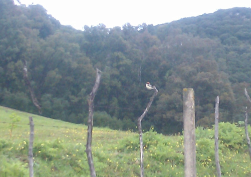
Returning to Córdoba, I followed the CP248 country road contouring east from the site, spotting a woodchat shrike on the way to a junction where a path to Córdoba was signposted down a stream The rain had started teeming down again and the path, paved and ancient, (surely Moorish if not Roman?) proved impossible to follow, broken by erosion, clogged by bushes and at least ankle deep in water. Reluctantly returning uphill to the junction, I turned right (east again) and followed the CP201 which led down from the hills to the city.
the Woodchat shrike
Before leaving Córdoba, I had to visit the famous Mezquita, and did so in the free early Monday morning slot (8-10am). Its a truly fabulous building, though inevitably crowded at that time with cheapskates like me. Note that the security staff start their sweep to clear out visitors around 9.30, so don’t leave it late.
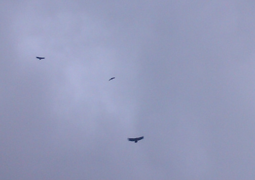
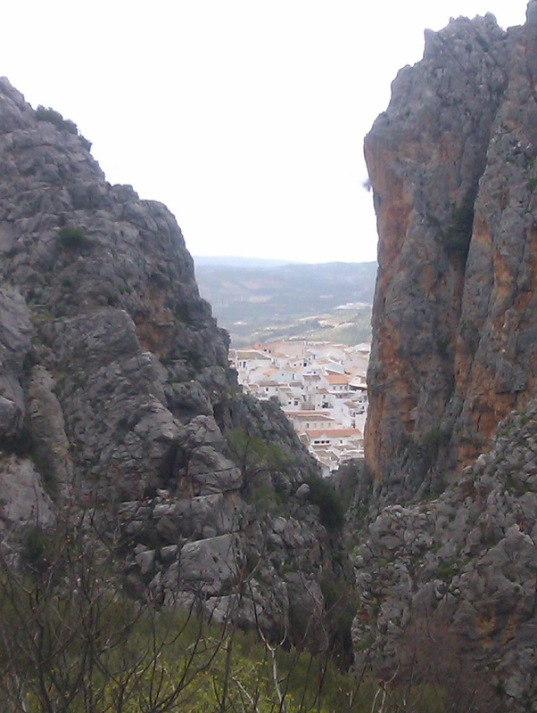
The aim here was to spend a couple of days in the La Subbética mountains an hour or so south on the bus. Zuheros sounded like a good base, and was. First trip out was a leisurely head down to the canyon to the west of the village and up through the cleft in the cliffs. This is where you take what I assume is the classic Zuheros picture. Pleasingly, vultures soared about above. The river through was (I think unusually) full and I didn’t fancy crossing it, so cut short the walk.
The next day I had booked a place at the Cueva de los Murcielagos (bat’s cave), the local ‘sight’. I arrived early after walking the four km up the signposted road and enjoyed the view at almost 1000 meters. I was surprised how many people turned up - maybe 25? - and despite being the only non-Spaniard, the nice guy leading the tour did a quick translation just for me as he pointed out the main features of interest (“Mr David, here the bones...” etc). It was interesting enough, but a cave is a cave...? I had a 10 km hike planned half way down the road, from Clive Jarman’s book on local walks which I had bought at the hotel, so I fended off the generous offers of a lift on the return leg. And this proved fine; easy and pretty, if a bit damp. In the evening, the Semana Santa celebrations involved a marching band winding through the narrow streets; not quite up to the scale of what was going on in Córdoba.
The next day I had booked a place at the Cueva de los Murcielagos (bat’s cave), the local ‘sight’. I arrived early after walking the four km up the signposted road and enjoyed the view at almost 1000 meters. I was surprised how many people turned up - maybe 25? - and despite being the only non-Spaniard, the nice guy leading the tour did a quick translation just for me as he pointed out the main features of interest (“Mr David, here the bones...” etc). It was interesting enough, but a cave is a cave...? I had a 10 km hike planned half way down the road, from Clive Jarman’s book on local walks which I had bought at the hotel, so I fended off the generous offers of a lift on the return leg. And this proved fine; easy and pretty, if a bit damp. In the evening, the Semana Santa celebrations involved a marching band winding through the narrow streets; not quite up to the scale of what was going on in Córdoba.
To Cabra
The next day was intended as ‘a big one’, over the mountain to the medium sized town of Cabra, from where I would return the next day to Córdoba, connecting with the Malaga train and the flight home. Roughly following a walk in the Jarman guide, I followed a path west, below the great wall of cliffs which the Subbética rises from. However soon enough, I realised that I had missed a turn-off and so headed up the mountain at the first opportunity. At the top, it was cold, misty and damp, with no sign of life among the limestone pavements and derelict fields apart from turf and stones rooted up - a sure sign that wild boar were common at in the night. As the Subbética is basically a large block of upland rock though, I was reasonably confident of finding my bearings, and so long as I stayed high and headed west and south, I should arrive above Cabra in due course. After a couple of hours, sure enough the view opened up to a white town below, nestling under the mountain. However, after doing a few calculations on time, distance and orientation, I realised that this was in fact Doña Mencía, only a few km from Zuheros, and to the north...I must have walked round in almost a circle. (This is where I have to confess with considerable embarrassment that I don’t do compasses...).
The next day was intended as ‘a big one’, over the mountain to the medium sized town of Cabra, from where I would return the next day to Córdoba, connecting with the Malaga train and the flight home. Roughly following a walk in the Jarman guide, I followed a path west, below the great wall of cliffs which the Subbética rises from. However soon enough, I realised that I had missed a turn-off and so headed up the mountain at the first opportunity. At the top, it was cold, misty and damp, with no sign of life among the limestone pavements and derelict fields apart from turf and stones rooted up - a sure sign that wild boar were common at in the night. As the Subbética is basically a large block of upland rock though, I was reasonably confident of finding my bearings, and so long as I stayed high and headed west and south, I should arrive above Cabra in due course. After a couple of hours, sure enough the view opened up to a white town below, nestling under the mountain. However, after doing a few calculations on time, distance and orientation, I realised that this was in fact Doña Mencía, only a few km from Zuheros, and to the north...I must have walked round in almost a circle. (This is where I have to confess with considerable embarrassment that I don’t do compasses...).
So, I headed south across the mountain in the opposite direction. The wind and rain began to get more intense, and I sheltered under a tree for a bit. As it appeared to ease off, I began looking for an opportunity to get off the mountain and down to the ‘via verde’ - one of the the former railway tracks which has been converted to a walking/cycle path. Of course, this wasn’t as easy as I thought, and a good hour was spent slipping down the wet hillsides, battling through the forest, bushes, undergrowth etc until eventually, I arrived at the edge of a field of olive trees. Even here though, the bare, sodden earth was sticky and hard to get through, especially crossing the eroded mini-ravines. All of a sudden I found myself on a flat, even path, and realised that this was the Via Verde! It was a relief to be warmer at the lower altitude and out of danger of getting totally lost. After basically stumbling around for most of the day, it was also great to know that you could just clock up the miles by pressing on, and in two or three hours of quick walking I arrived in Cabra. Here, I found that the hotel I had booked (Fuente de Piedra) was another three km distant, which I could have done without; however, I got there just before the rain returned with a vengence in a thunderstorm, so I can’t complain.
The next day (my final one) was the Thursday before Easter. I waited at the bus station for my morning Córdoba bus, which didn’t arrive. Of course it turned out to be a ‘festivo’ (holiday), with a severely restricted timetable, which I hadn’t thought to check. By lunchtime, the scheduled festivo service was over half an hour late and the prospect, not particularly appealing, of being marooned in Cabra loomed. A direct Malaga bus appeared - I didn’t know there was such a service - but the Córdoba bus turned up eventually and all was well.
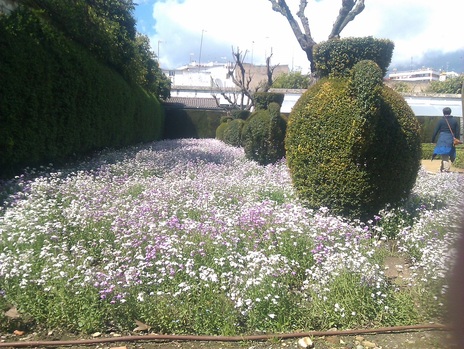
The Alcazar gardens, Córdoba
The Alcazar gardens, Córdoba
