This is an account of a week spent in the Garfagnana area north of Lucca in July 2013. The area seemed to have a reputation from guidebooks as a kind ‘undiscovered Tuscany’ which appealed. My plan was to follow some of a long distance trail called ‘Garfagnana Trekking’, which guide books bill as a nine-day circular loop of the upper valley.
Day one - Castelnuovo to Pieve Fosciana
I flew into Pisa from Edinburgh early evening and after an overnight stop caught the train direct to Castelnuevo de Garfagnana. Its amazing that a train runs to these villages along the Serchio valley, and it is also dirt cheap. The landscape opens up on the hour an a half trip from Pisa via Lucca, with forest all around and the train crisscrossing the tumbling river, below the peaks. I had only booked one night here at Pieve Fosciana, so I called into the Turismo (as I tend to call tourism offices, irrespective of nationality) to get some ideas. I was a bit scunnered when the nice lady there advised against going to the Apuan Alps, as there had recently been earthquakes, and it may be dangerous. So, that was it - Apuan Alps it was (I like anything geological!).
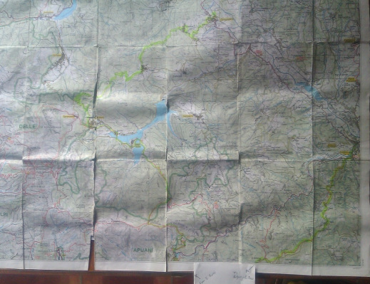
This is my map, with part of my route marked in green (its double-sided, so hard to get the southern section in the same photo!). A 1:25000 map is so much better that 1:50000...
(Carta dei sentieri e dei refugi Alpi Apuane 101/102)
(Carta dei sentieri e dei refugi Alpi Apuane 101/102)
After a quick look around the town, now I headed off to my lodgings, a B&B called Villa Belvedere in Pieve Fosciana early afternoon. I hadn’t realised that Pieve was several kilometers out of Castelnuevo; or indeed that the Villa was another km or two beyond Pieve....this is a mistake I often make when pre-booking accommodation: the hotel often is further than where had it appeared to be on the booking site map! The B&B, by the way, is lovely (and cheap) with a great swimming pool overlooking the majestic Apuan Alps and a cooked breakfast (unusual in Italy).
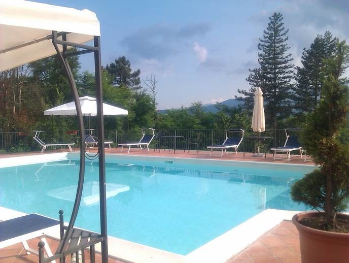
Villa Belvedere's pool and view
Day two - Pieve Fosciana to Rifugio Rossi
The next day, I planned to head for the Rifugio Rossi, up in the mountains. I had mixed feelings about this as it is has only a dormitory with 20-odd beds and I’ve never been a ‘hosteller’. Before setting out, the lady at the B&B warned that it would rain all day...hmm, nonetheless, I set off undeterred. A kilometer or two down the road, I was looking for the first of the Garfagnana Trekking (GT) signs, which I hadn’t spotted on the way up. My map (Toscoemiliano 25k-1) showed the path heading off east (left as I went down) at a cross roads. But there were no signs, and instead a small shopping centre. It appears that this had been built since the map was printed 20 years ago. This raised a familiar conundrum - is it best to follow the map? Or the waymarking? The answer, I’m afraid is both/either, I think. I found some new waymarking just further on, which took me though beautiful woods right down to the edge of Castenuevo. This wasn’t shown on the map which displayed an old and obsolete route for the GT. So the GT markings on maps need to be taken with a pinch of salt. I guess this is a common feature of all long-distance paths (GR routes etc) - detailed local routes change all the time as buildings, roads and land uses change.
After crossing the river and heading out of town, the first drops of rain started, bringing a strong sense of “what am I doing?” - but it lasted for five minutes and was clear for the next few days. Optimism triumphs. The hike up to the Refugio was fairly straightforward, though again I lost the path higher up past Sassi (where there was a nice wee bar) and had a long unplanned walk along a mountain track, the limestone peaks closing in all the time. The final assault was a steep climb through the wonderful beech forest (faglia, I think they are called in Italy) until at last, you emerge at the treeline; this is just below the refugio.
Arriving at around 5pm. I seemed to be just about the first to arrive. Around 15 people plus a few campers turned up over the next couple of hours, all Italian I think. The CAI folk looking after the Rifugio were friendly and helpful, getting me the necessary beer and giving me kind of sheets and blankets for the bunk of my choice. The meal that night was great, home-cooked food with wine and I slept pretty well, all things considered. However, with one toilet, no shower and a single dripping tap between 15 people, I looked forward to a hotel again the next night.
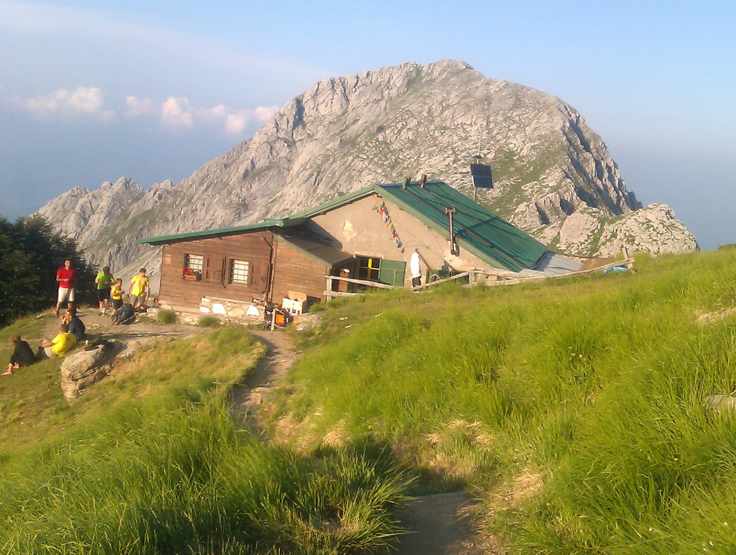
The Rifugio Enrico Rossi with the Uomo Morte (Dead Man) behind
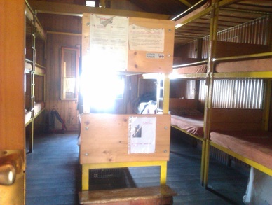
Rifugio Rossi's sleeping quarters. Mine was the bottom one, far right.
Day three - Rifugio Rossi to Vagli
Like most folk, I was up early and set off before 8.00, which was just as well given that this turned out to be the day from hell! The GT route is divided into 9 daily ‘stages’, and I thought that the next recommended stage to Isola Santa was too short. I had said this to the Turismo lady in Castelnuevo, but she said that doing two stages in a single day would be too much. Well, I’m not always good at taking advice, so I did it anyway, just about.
After settling the bill at the Rifugio (about 45 euros DB&B), the route took me up ‘Hell Valley’ to just below one of the high peaks (Pania della Croce, and 1800m). Although it looked a short distance on the map, it was maybe the steepest section of my trip, up shattered dazzling white limestone boulders, though with a good and clear path. This emerged at the crest to a fantastic panorama of limestone peaks all around and to the left, the towns of the Versalia coast, shimmering below. I gave the peak itself a miss, conscious of the long day ahead (just as well, it turned out) and set off down the great slope towards another Rifugio (Freo) a few thousand feet below. From the bottom, the path followed a lovely old mule track - I love these old ‘caminos’ that can still be found all over southern Europe - through woods and eventually down to the main road at Isola Santo in about 5 hours. This lakeside village was pretty, but twee and overrun by motorbikes zipping through, presumably a popular weekend pastime for the locals of nearby towns.
After settling the bill at the Rifugio (about 45 euros DB&B), the route took me up ‘Hell Valley’ to just below one of the high peaks (Pania della Croce, and 1800m). Although it looked a short distance on the map, it was maybe the steepest section of my trip, up shattered dazzling white limestone boulders, though with a good and clear path. This emerged at the crest to a fantastic panorama of limestone peaks all around and to the left, the towns of the Versalia coast, shimmering below. I gave the peak itself a miss, conscious of the long day ahead (just as well, it turned out) and set off down the great slope towards another Rifugio (Freo) a few thousand feet below. From the bottom, the path followed a lovely old mule track - I love these old ‘caminos’ that can still be found all over southern Europe - through woods and eventually down to the main road at Isola Santo in about 5 hours. This lakeside village was pretty, but twee and overrun by motorbikes zipping through, presumably a popular weekend pastime for the locals of nearby towns.
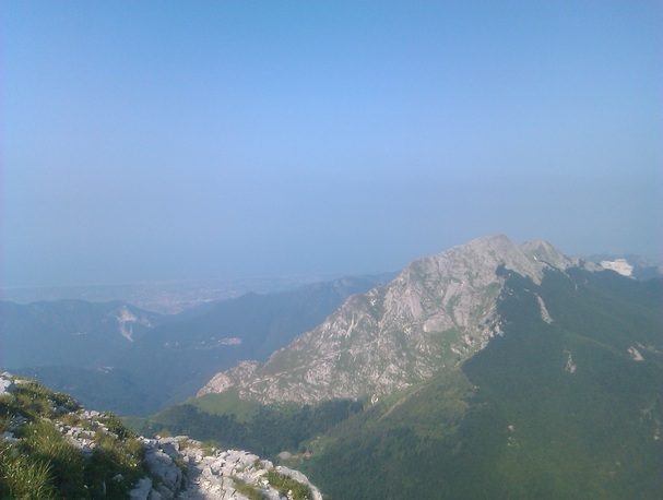
The coast in the distance from just below Pania delle Croce
The path headed up to the village of Capanne di Carregine where I tried to get a drink in the local bar, but after being ignored for 15 minutes, left and continued upward and onward. Past the village church, the path through the thick woods seemed really heavy going, partly due to the steepness and partly the heat and humidity. Eventually, the path came out at high meadows through a rock cleft, past abandoned hamlets, carpets of wild flowers and with great views back across Isola Santo to where I had come from in the early morning. But it seemed to go on forever, my mood not helped by meeting an elderly Pole who told me the ascent was easy, as he skipped down past me. As always, if you keep on going, you’ll eventually get to the end. And so, at last, the path crested the ridge where my way was a country track led to the right, another path leading off to the left towards the peak of Sumbra. I needed a good rest before setting off and finished my second liter of water. The next stage was down through the beech forest again, this time crisscrossing an ugly forestry track to a junction, where a poorly signed GT route headed down a forested valley towards Vagli, my destination. This also appeared endless, with fallen trees often blocking the route, even when flattening out at the end. Finally, the route traipsed a few unwelcome extra km around the lake. It's probably very pretty, but when exhaustion sets in, it's hard to appreciate such things. Two cold beers at the friendly Hotel delle Alpe improved matters after I staggered in, and after a good shower and rest, dinner was again excellent.
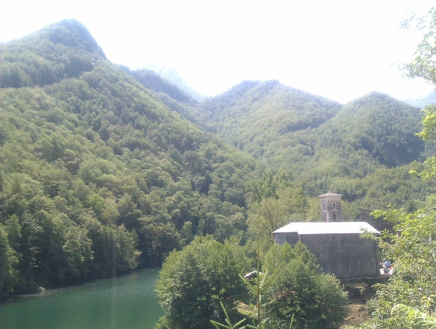
Arriving down to the lake and hamlet at Isola Santa
Day four - Vagli to Camporgiano
The next day, I had the choice of heading further round the GT trail, or wimping out and spending a couple of days recovering. I’m not proud to say I chose the latter. But I got another good walk in first, making up my own itinerary to the railway line at Camporgiano. Although this was a fair way, it was pretty flat - the previous day had involved two descents of about 3,000 feet as well as a similar ascent and that’s what really does you in. Leaving the lakeside village of Vagli, I watched the amazing quarry trucks pass, each carrying two blocks of marble about the size of a cricket pavilion. I lost the path up to the higher village of Vagli Sopra (damn it - I knew I should have taken the short road route) wasting an hour or two. But after a quick orangina in the village bar (where the lady gave me free bottled water), I got to the crossroads at the pass above, and took the Roggio turning to the right. Immediately, there was a barrier, saying that the road was closed due to earthquake damage, but I assumed (correctly this time) that it would be OK on foot. After a km or two on the pleasant dirt track in open countryside, I came across a section of boulders which had fallen down the hillside; a bulldozer was parked just above up, having dislodged more loose debris.
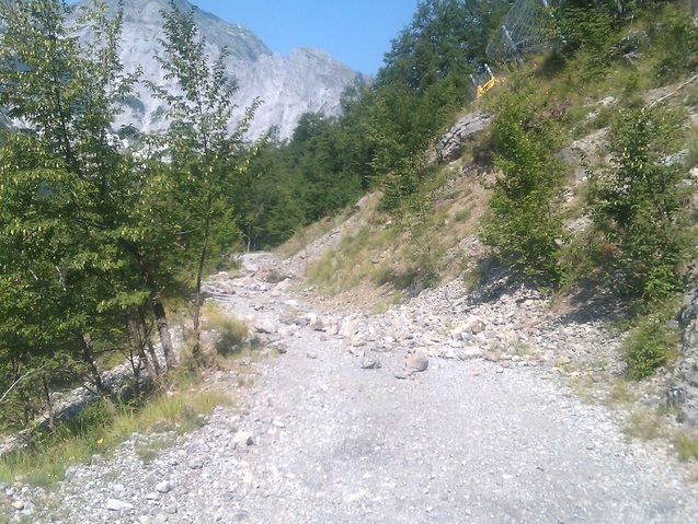
Earthquake damage on the road to Roggio. The bulldozer and safety fence are up to the right
The road meandered to the next village, Roggio, where I stopped and admired the swallow (or are they swifts? or housemartins?) swooping around the church tower. Roggio is a typical village - crowning a steep little hill with old houses clustered round the church, but not marked as of any significance on maps as such antiquity is so commonplace in these parts. From there, another unsurfaced road towards the main valley led off through thick woods. Signposts described the fungi of the route; no doubt popular to eat locally. You make quick progress on these flat roads and I found myself at Camporgiano mid-afternoon, past its squat castle and down to the little railway line, where I headed to the touristic delights of Bagni di Lucca, back down the valley. Bagni is pretty but with its faded grand houses of the 19th century rather melancholy, possibly dull even, but it had what I was after - nice hotels!
Day five - to Cocciglia and back
Based in Bagni now, I did my last real excursion, up the Lima valley. A map from the local Turismo showed a ‘roman bridge’ marked between Pallegio and Cocciglia about 8 km up the valley, and I decided I needed to investigate. Especially as my guide books say that the hot springs at Bagni appeared to to be known to the romans, which seems strange. Unfortunately, and crazily, there’s only one bus a day up the Lima valley and that leaves late afternoon. So I had to slog up the main road, moderately busy with cars and trucks, planning to return to Bagni along the byroads through the villages on the north side of the valley. My map showed some more non-existent walking routes, so I made a couple of false starts before arriving at Palleggio, and found the old, but unremarkable bridge pretty quickly; it was short, but high across the small canyon and didn’t look roman to me; however, there was ‘roman-style’ paving in the woods leading to and from the bridge through the woods, and one stone seemed to be inscribed with a roman ‘IV’. So I reckon it probably was Roman. Anyhow, the return path through the villages like San Gemignano and Longoio was much better, though all along minor tarmac roads until the end of the road at the chapel Madonna della Serra, where a path falls though the woods to emerge in Bagni town. The highlight is the wonderful old Pisan church at San Cassiano, unfortunately locked.
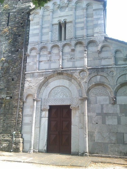
The ancient church tower and facade at San Cassiano
And that was the hiking done; the last day there were some typical, wonderful Italian thunderstorms and I had time to spend a few hours in lovely Lucca on the way back to Pisa, taking in the Cathedral, museum and the de riguer picnic on the old city walls. The strangest thing to me was, in the whole trip, I never saw a single bird of prey. In any other country, there would be hawks, buzzards or even eagles circling above forests and mountains as wild as this. What do they do with them in Italy?
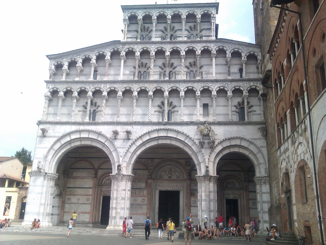
A (squint) view of Lucca's cathedral. I like the man hugging a bear.
