Cirque d'Infernet
This week was spent in south west France. I had booked a flight to Toulouse and return from Marseille, originally considered following the GR653 (E7) long distance route from Toulouse heading east as far as I could get in a week. An alternative would be to stick to the Canal du Midi south of Toulouse, which would allow a straightforward route to Carcassone, Beziers or any points: as I say on my home page, I always find a linear walk more appealing than a circular one. In the end, I decided not to do the first because of a fear that the accommodation in the Haut Languedoc park may be scarce at this time (October/ November). And I decided not to do the latter because, interesting and easy though it is, I think I would get bored of walking along a canal towpath for a week. And there would be no suspense without any possibility of getting lost, as usual!
For maps, I used the wonderful IGN series Blue maps (2643OT, 2743ET, 2943 ET); surely the best cartography in the world and a reason in itself for choosing France as a hiking destination...Another great asset was the Topo Guide for the GR653 Arles to Toulouse section; however, because I was going the other way to the route described (eastwards), the detailed directions are pretty hard to work out (especially in French!). Unfortunately, I hardly took any pictures on this trip, so some of these are lifted from the inter web. The first part of the route is marked here: https://www.wikiloc.com/wikiloc/spatialArtifacts.do
For maps, I used the wonderful IGN series Blue maps (2643OT, 2743ET, 2943 ET); surely the best cartography in the world and a reason in itself for choosing France as a hiking destination...Another great asset was the Topo Guide for the GR653 Arles to Toulouse section; however, because I was going the other way to the route described (eastwards), the detailed directions are pretty hard to work out (especially in French!). Unfortunately, I hardly took any pictures on this trip, so some of these are lifted from the inter web. The first part of the route is marked here: https://www.wikiloc.com/wikiloc/spatialArtifacts.do
So this was to be a bit of a hybrid effort, splitting the route from le Bousquet d’Orb in the Haut Languedoc to Arles on the provence border by skipping through Montpellier on public transport. I started with a short walk from Toulouse airport to the city centre, enjoying the small-town sights of Blagnac immediately outside the airport, and the banks of the impressive River Garonne into the historic heart of Toulouse, cormorants occupying the river. I took the train to Beziers for the night, to catch the early morning train into the highlands north, joining the GR653 and heading east.
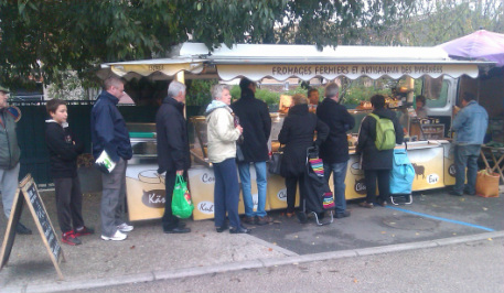
First sight out of the airport....a queue for cheese at the local market in Blagnac. Reasuringly, typically French...
Day one - Le Bousquet d'Orb to Lodeve
So the first proper walk begun at the small station of le Bousquet d’Orb, after an hour on the train heading into the hills, where the waymarking for the GR653 was easily picked up. First up was the delightful and ancient village of Lunas at the confluence of several small rivers. I detoured to see the very early Christian chapel of St Georges,but in truth it’s barely worth seeing. My destination for the night was Lodeve and, anxious that I would get there by dark, I cut out Joncels, to take a short cut up the Sourlan country road. But I headed straight on too far and missed the turn right (despite it being well signposted) across the valley. However once regained, the path was easy to follow, but with a freezing northerly wind at around 600 metre altitude. Patches of ice appeared on the higher sections - this was not a trip for picnicking. Before too long, Lodeve came in sight; however as so often, it then seemed to take forever to actually arrive at the place. Lodeve itself appeared pretty depressed, dismal and dead. The lady at the Hotel du Nord was keen to establish that I hadn’t been staying at certain local hostels which apparently had some kind of infection; my French wasn’t good enough to establish what this was, but I guessed fleas. The only sign of life seemed to be a couple of Chinese restaurants.
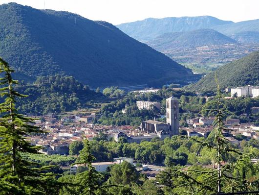
The view coming down to Lodeve from the west; the path ascends through the woods on the other side of the valley. The hills above St Guilhem are in the distance.
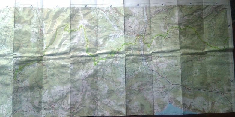
My 'serie blue' map 2643OT from le Bousquet to St Jean de Blaquiere
(also used 2642ET, 2943ET)
(also used 2642ET, 2943ET)
Day two - Lodeve to St Guilhem le Desert
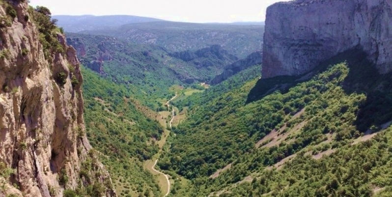
The next stage, to St Guilhem le Desert, was a big one so I was keen to get off early. The first section, through the oak woods climbing east of Lodeve, over the autoroute tunnel were delightful and along the way, there are some spectacular rock ledges with wonderful views over to the right (south) and the peak of St Baudille to the north a constant reference point. I stopped briefly at the Grandmont Priory, apparently an ancient pilgrim halt and also tried and failed to find a couple of prehistoric dolmens on the route. Halfway, the GR653 descends from the mountains to the small town of St Jean de la Blaquiere, just below the Languedoc plateau. It was here that I started to get lost. Climbing back into the forested hills east of St Jean, the IGN map, the Topo guide and visual intuition began telling divergent stories. I came down the valley towards Montpeyroux seemingly on the wrong (south) side. Not wanting to head south any further than necessary, I cut through the hamlet of Arboras, and failed to pick up the expected waymarking, so I eventually decided to head across country, aiming the the hills above the Cirque d’Infernet. I’m sure this was a stupid thing to do, but somehow i found myself back on the GR path below the hill of Pioch Canis, which led directly to St Guilhem. After following the crest of the hills for an hour or two, the path arrives at the lip of the Cirque, which is a breathtaking sight, all limestone cliff and pine forest. It took a full hour to descend, arriving in St Guilhem at dusk (just made it)!
Day three - St Guilhem to Montarnaud
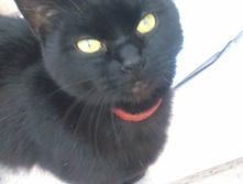 The cat at the council offices, Montarnaud
I was too tired and sore to look around the village, which is certainly quaint and historic, but every other house is a restaurant, or souvenir shop anyway and prices are definitely a bit on the steep side. So, the path south is along the main road, slightly spoiling the views of the lovely Herault tumbling through its gorge, with ruined mills every few hundred metres. The mountains end at the ancient Pont du Diable, where vinyards abruptly take over from the mountain forests and the path goes to Aniane, another old town on the Herault floodplain. From there, the GR653 crosses another low range of hills, following the path of a disused railway through a land of scrub, red earth and abandoned quarries. This bit dragged for me, and arriving at Montarnaud, I decided that this would do for the day, rather than press on another 15 km to Montpellier. A friendly cat waited with me for the bus outside the council offices.
Day four - Verguez to St Gilles
After a night in Montpellier, it was an early train to pick up the GR653 at Verguez. The weather forecast was for rain, so I hoped to get as far as possible before it started...this being southern France, it might not rain anyway...? Just south of the station, I noticed a crossing road was called ‘Rue de la Monnai’ - I had read that this was a name given to Roman roads, especially where they had been plundered for building materials. And sure enough the Topo Guide confirmed this was indeed a roman road, though tarmacked over so nothing to see now. I imagine that this would have been used by some of the pilgrims on the Compostela route in medieval times? I followed the irrigation canal east, past the massive Perrier water plant and turning right at the Mas d’arnaud, rejoining the GR at Ponthieu. Crossing the town of Vauvert, I had some difficulty in picking up the waymarks again, but did so as the first drops began. It rained for the rest of the day; steady, heavy and cold rain.Route-finding was straightforward, using the reliable waymarks and the Topo guide as I ploughed through the vineyards and grey country roads, getting from ‘wet’ to soaked’. Arriving at the irrigation canal once more, there was nothing more for it than slogging onwards as fast as possible through the bleak landscape; the only respite would come on arrival at St Gilles, the destination for the night. With flat terrain and no navigation problems, I found I could do four or maybe five km an hour, by gritting the teeth and and eventually arrived at St Gilles mid afternoon in record time (for me). Half my gear (change of clothes etc) was soaked and I flopped out before a decent meal with wine at the canalside restaurant cheered me up a bit.
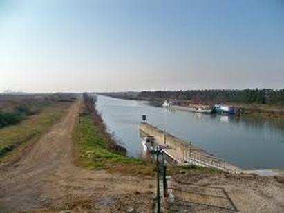
The endless canal, near St Gilles; it's even duller in the rain...
Day five - St Gilles to Arles
The last leg looked - indeed was - a straightforward hop across the first section of the Carmargue delta to Arles, my final destination (being on the frequent train line to Marseille airport). The choice was to follow the GR653 across the drained fields, or to follow the Petit Rhone which looped to the North. In the event, I did the former, but as the way was entirely on flat country roads, it was tiresome; I would try the river route next time. The land was amazingly dry after the torrents of the previous day, but I was disappointed at the bird life - a few egrets and herons, whereas I had seen various birds of prey before. Not having been to the Carmague before, it disappointed; maybe a bit more time and a bike is the thing to do? However, arriving in Arles was wonderful; touristy with its Van Gogh connections and Roman sights, but with a life of its own. I stayed at the wonderful Hotel d’Arlatan, which I took ages to find, but is right in the old town. Part of the hotel walls are the remains, it seems of the Roman basilica - and there are other roman fragments to be viewed in the basement through a glass floor panel. The staff were nice and so was the breakfast. I can’t remember where I had dinner, but it was also brilliant! The next day, I took in some of the local sights, like the moderately interesting roman necropolis of Les Alysecamps and the sun shone warm enough to enjoy a cold bottle of beer in the park before the train came. That’s the way I like to end a trip...
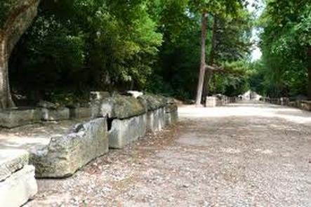
The Roman necropolis at Arles
